• The fall season brings cooler weather and a packed schedule to the Trinity Peninsula. Community organizers are preparing a full slate of activities for September and October 2026. Tracking these local gatherings helps business operators anticipate weekend foot traffic and allows families to plan their schedules. You can review exact dates and times on our community events calendar to stay informed about what is happening across the county.

    Late September Family Nights And Faith Gatherings

    Local churches and first responders host several major events in late September that draw families from across East Texas. On Friday, September 25, a large Ladies Bible Study group meets in Trinity at 6:00 PM. Faith-based conferences generate immediate sales opportunities for nearby restaurants and coffee shops as attendees gather for meals before and after the services.

    The following day, Saturday, September 26, the New 356 Volunteer Fire Department hosts its Family Fun Night starting at 11:00 AM. Volunteer fire department events act as central community anchors. They raise operating funds for local first responders and provide safe entertainment for children. Supporting these local departments directly improves emergency response capabilities across the region. Residents can review statewide fire safety standards through the Texas A&M Forest Service. Strong turnout at these Saturday events translates into steady weekend sales for the grocery stores and hardware suppliers providing the event materials.

    October Auctions And Pageants

    Civic organizations ramp up their public outreach in October. Saturday, October 10, 2026, serves as a busy weekend for the city of Trinity. The Trinity Community Center will host the 8th Annual Lavender & Lace Silent Auction and Style Show, beginning at 10:30 AM. Charity auctions encourage direct community investment. Local retailers donate goods and services, gaining direct brand exposure to hundreds of potential customers. The funds raised support local scholarships, municipal beautification projects, and civic charities.

    On the exact same morning, the Pink Pajama Party Pageant takes place at 131 N Elm Street in Trinity, starting at 10:00 AM. Youth pageants and local talent shows bring out-of-town relatives and visitors into the city limits. This sudden influx of visitors fills local hotel rooms and increases demand for retail shopping. Connecting with state tourism boards helps regional hospitality managers market their fall promotions to these traveling families.

    Autumn activities on Lake Livingston begin to shift away from water sports toward camping and localized fishing tournaments. Marinas and state parks prepare for late-season visitors who prefer cooler temperatures. Families planning to explore the natural surroundings check local park schedules to secure camping permits and review updated trail maps. Keeping public parks accessible attracts campers who spend money at local bait shops and convenience stores across the Trinity Peninsula.
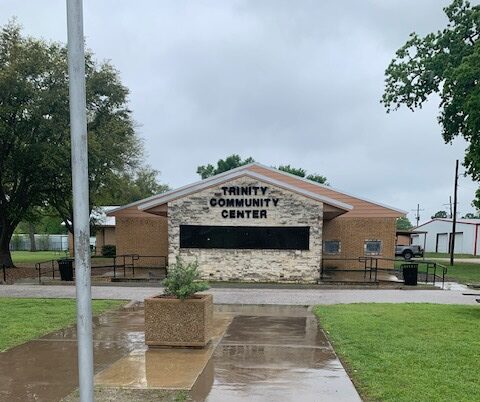
    Trinity County Community Center

    Professional Training And Agricultural Development

    Fall schedules extend beyond weekend entertainment to include professional development. On Friday, September 11, local agricultural workers and municipal staff will attend the 2026 Houston County 5 Hour CEU Conference and Training near Groveton, starting at 8:00 AM. Continuing education programs bring technical specialists and state regulators into the immediate market. Professionals traveling for these seminars require catering, fueling stations, and meeting supplies.

    Event DateLocationEvent FocusCommunity Impact
    September 11, 2026Groveton AreaCEU Conference & TrainingBrings professional development and networking to the region.
    September 25, 2026TrinityLadies Bible StudyBoosts evening restaurant and hospitality demand.
    September 26, 2026New 356 VFD, TrinityFamily Fun NightRaises funds for first responders and drives weekend traffic.
    October 10, 2026Trinity Community CenterLavender & Lace AuctionConnects local retailers with civic fundraising.
    October 10, 2026131 N Elm St, TrinityPink Pajama Party PageantIncreases local retail and weekend lodging demand.

    Keeping agricultural certifications current protects the local farming economy. Farm owners rely on these educational sessions to learn about new soil management techniques, water conservation methods, and livestock health protocols. Tracking these regional schedules keeps Trinity County business owners informed and prepared for the upcoming season.

  • Port Townsend’s Lawrence Street project is scheduled to begin construction on September 14, 2026, after the Wooden Boat Festival has concluded, with work focused on Lawrence Street between Harrison Street and Walker Street. The City of Port Townsend Public Works Department says the project is expected to take about 140 working days, or roughly seven months, with construction concluding in early summer 2027, according to the city’s construction notice. For residents, business owners, transit users, and drivers, the next civic step is practical: review posted detours, watch for public notices about transit changes, and plan for construction activity along this central corridor.

    What The Lawrence Street Project Changes

    Lawrence Street Project Scope

    The Lawrence Street project will reconstruct the street between Harrison and Walker, addressing subgrade and pavement deterioration identified by the city. The city’s stated scope includes bike facilities, sidewalk repairs, accessibility upgrades under the Americans with Disabilities Act, and closure of existing sidewalk gaps. Public Works has described the goal as creating a fully accessible route between Harrison Street and Walker Street.

    The work is limited to a specific section of Lawrence Street, but it affects a corridor used by drivers, pedestrians, cyclists, nearby residents, and people reaching local services. The Washington State Transportation Improvement Board lists the improvement length at about 0.33 miles and identifies the grant-supported work through its project dashboard. That short distance matters because it connects several blocks where existing pedestrian facilities are uneven from one side of the street to the other.

    Pedestrian And Bicycle Connections

    According to the city, existing pedestrian infrastructure is incomplete. A continuous sidewalk is already in place along the north side of Lawrence Street for six blocks from Harrison to Walker. On the south side, sidewalk exists from Harrison to Benton, but no sidewalk exists for the three blocks between Benton and Walker. Closing those gaps is one of the clearest day-to-day changes residents should expect from the project once construction is complete.

    Bike facilities are also included in the city’s project scope. The public notice does not provide a block-by-block operating plan for cyclists during construction, so residents should rely on posted signs, city notices, and work-zone direction once crews are in place. The planned improvements are civic infrastructure work, not a one-day event, and the effects will be felt in stages as crews move through street, sidewalk, and utility work.

    Construction Schedule And Daily Access

    September 14 Start Date

    Construction is scheduled to start on September 14, 2026. The city specifically timed the start after the conclusion of the Wooden Boat Festival, which helps avoid beginning construction during one of Port Townsend’s major public event periods. As of September 7, 2026, the work has not yet begun, so residents still have time to adjust travel patterns and watch for official construction messaging.

    The city estimates about 140 working days for construction, which places completion in early summer 2027. Working-day schedules can be affected by weather, utility conditions, materials, or field findings, but the research provided by the city supports that seven-month estimate. Residents who use Lawrence Street daily should expect conditions to change over the life of the project rather than remain fixed from the first week through completion.

    Detours, Driveways, And Transit Notices

    During construction, traffic will be managed with road detours, message boards, signs, and flaggers, according to the city. Driveway access is expected to be maintained, with coordination for any disruptions. That point is important for households and businesses along the work zone because it means the city has identified access management as part of the construction plan, though some short-term interruptions may still require direct coordination.

    Transit riders should also pay attention. The city has said bus or transit routes and stops may be affected, with advance coordination and public notice. The press release does not list specific route changes, stop closures, or dates for those transit adjustments, so riders should not assume a change until an official notice is posted. In the week before September 14, 2026, the most useful step is to check city updates and on-street message boards near Lawrence Street.

    • Construction area: Lawrence Street from Harrison Street to Walker Street.
    • Scheduled start: September 14, 2026.
    • Estimated duration: about 140 working days, or roughly seven months.
    • Traffic controls: detours, message boards, signs, and flaggers.
    • Access: driveway access maintained with coordination for disruptions.

    Funding, Utilities, And Public Accountability

    Public works crew area with utility markings along a city street

    Grant And Local Funding

    The project received approximately $2.9 million in grant funding from the Washington State Transportation Improvement Board in 2024. The city estimates the total project budget, from design through construction, at $4.3 million. Funding sources identified in the city’s notice include the Transportation Improvement Board, the city’s Transportation Benefit District, and utility funds.

    For Port Townsend residents, the funding mix matters because the work is not limited to pavement. Transportation dollars and utility funds are being combined for a corridor project that includes surface reconstruction and underground systems. That approach can reduce repeated disruptions on the same street when roadway and utility needs are addressed in the same construction window, though the city’s notice does not provide a separate cost breakdown for every category of work.

    Water, Sewer, Stormwater, And Street Work

    Utility upgrades are part of the planned construction. The city lists water, sewer, and stormwater systems in the scope. Stormwater conveyance pipes, catch basins, and rain garden planting areas are also planned. Those details indicate that the Lawrence Street project is both a transportation improvement and a public works utility project.

    The stormwater elements are especially visible because they affect how water moves through the corridor during rain events. The city’s notice identifies rain garden planting areas, but it does not provide planting species, maintenance schedules, or final design details in the research provided here. Residents with property access questions, delivery concerns, or mobility needs should contact the appropriate city project channels when notices are issued rather than relying on informal construction updates.

    Local business readers interested in how infrastructure work impacts main-street access in other regions can check out the related chamber network via the Richland Chamber’s website. For Port Townsend, the verified construction details remain the city notice and the state transportation project record.

    Lawrence Street Project Civic Checklist

    What Residents Can Do Before Work Starts

    With the Lawrence Street project scheduled to begin on September 14, 2026, residents have a short window to prepare. People who live, work, walk, bike, or drive near Lawrence Street should identify alternate routes before crews begin. Property owners along Harrison-to-Walker should watch for direct coordination about driveway access, especially if deliveries, mobility equipment, medical transportation, or business access must be planned around work activity.

    Transit riders should confirm any stop or route notices before leaving home once construction begins. The city has said transit impacts may occur, but the research does not identify the exact stops or timing of those changes. Pedestrians should also expect temporary changes because sidewalk repairs, sidewalk-gap work, ADA upgrades, and street reconstruction cannot all occur without work-zone controls.

    Questions To Track Through Early Summer 2027

    Several public questions will remain active as construction proceeds: how detours shift by phase, when utility work reaches specific blocks, how driveway coordination is handled, and when sidewalk gaps are closed. The city’s estimated completion period is early summer 2027, so residents should treat the work as a months-long civic project rather than a brief closure.

    The verified facts show a defined corridor, a September 14, 2026 start date, a roughly seven-month schedule, a $4.3 million total budget, and a public purpose tied to pavement, sidewalks, accessibility, bicycles, and utilities. The Lawrence Street project will likely be most disruptive while crews are active, but it is also the scheduled public works investment that will determine how this section of Lawrence Street functions for drivers, pedestrians, cyclists, and utility users after early summer 2027.

  • The Smoketown Block Party took place on Saturday, August 29, 2026, after Louisville Metro officials rescheduled the neighborhood celebration because of inclement weather. The event marked the completion of seven permanent affordable homes tied to the Smoketown Community Land Trust, with activities set for Hancock Street between Lampton and Jacobs Streets from 2:00 p.m. to 6:00 p.m., according to a Louisville Metro Government notice from Councilman Herndon city announcement.

    What The Smoketown Block Party Marked

    Smoketown Block Party Details On Hancock Street

    The public celebration centered on a ribbon-cutting for seven completed affordable homes in Smoketown. City officials described the event as free and family-friendly, with a roller-skating rink, bounce house, food trucks, “brain freeze” treats, resource tables, and local vendors included in the day’s schedule. The official notice placed the celebration on Hancock Street between Lampton and Jacobs Streets, making the block itself part of the public recognition of the housing work.

    The event had first been planned for August 1, 2026, before the weather-related change moved it to August 29, 2026. A District 4 e-news notice described the original plan as a block party and ribbon-cutting with home tours and on-site pre-qualification screenings for potential buyers. That same notice said SmoketownCLT was incorporated as a 501(c)(3) in March 2024 and described the seven-home completion as the organization’s first major milestone District 4 notice.

    What Was Documented By The City

    For residents who could not attend, the official notices provide a clear record of what was scheduled and why the event mattered to the neighborhood. The city information identifies the project as seven permanent affordable homes, rather than a temporary housing effort. It also places the work within Smoketown, a Louisville neighborhood where public attention to affordable homeownership has been tied to a community land trust model through SmoketownCLT.

    The city notices reviewed for this report did not provide attendance totals, buyer names, sale prices, or a post-event count of completed home tours. Because those details were not included in the official materials available here, this report does not make claims about turnout, final buyer selection, or the full financing structure behind the homes.

    Affordable Housing And The Community Land Trust Model

    Why Permanent Affordability Was The Core Point

    The civic significance of the celebration was not limited to a one-day neighborhood event. The key public purpose identified by Louisville Metro was the completion of seven permanent affordable homes. In housing terms, that wording matters because it signals that the homes are meant to remain affordable beyond the first household that buys them.

    The materials provided in official city notices point to SmoketownCLT as the organization connected with the homeownership effort. They do not list every legal tool used in the project, so residents seeking a full explanation of resale rules, income qualifications, or purchase steps should rely on direct information from the city or SmoketownCLT rather than secondhand descriptions. Still, the public record does show that the August 29 event was meant to introduce residents to affordable homeownership resources, not simply celebrate new construction.

    That distinction affects civic engagement. A ribbon-cutting can be ceremonial, but resource tables and pre-qualification information can help residents understand who the homes are intended to serve and what steps may be required before a buyer is approved. For Smoketown households interested in staying in the neighborhood, access to clear information is part of the value of holding such an event in public view.

    Questions Residents May Still Track

    Several public questions remain reasonable after the celebration because they were not answered in the official notices reviewed here. Residents may want to know how buyer eligibility is determined, how long affordability protections remain in place, how resale limits are explained to buyers, and whether future phases are planned. Those are policy questions as much as real estate questions, because the answers shape who benefits from public or nonprofit housing efforts over time.

    • Which households qualify for the affordable homeownership program?
    • What public updates will be available after the ribbon-cutting?
    • How will long-term affordability be tracked and reported?
    • Where can residents find official application or pre-qualification instructions?

    For the city, the Smoketown Block Party served as a public-facing point in a housing process that residents can continue to follow through council updates, neighborhood meetings, and official notices. For community members, the next civic step is to look for documented information from Louisville Metro and SmoketownCLT before making decisions about applying or advising others to apply.

    Neighborhood Event Planning And Public Access

    Why The Rescheduled Date Matters

    The shift from August 1 to August 29, 2026, is a small but practical detail for public accountability. When a city-backed or council-promoted event is rescheduled, residents need accurate timing, location, and activity information. Louisville Metro’s rescheduled notice supplied the key public details: the date, time, block location, reason for rescheduling, and a list of planned activities.

    That type of information is especially important for families, older residents, people arranging transportation, vendors, and groups planning to share housing or community resources. A neighborhood block party tied to housing policy is not only entertainment; it is also a public information channel. If residents miss the notice, they may miss a chance to ask questions in person about affordable ownership or learn which offices and organizations are involved.

    How The Event Connected Services And Celebration

    The activity list showed an effort to draw a broad neighborhood audience. Food trucks, treats, skating, and a bounce house made the event accessible to families, while resource tables and homeownership information gave it a civic purpose. The official notices did not say which vendors or resource groups appeared at the final rescheduled event, so this report does not identify participating organizations beyond the entities named in the city materials.

    That caution matters. Local reporting on civic events should separate what was announced by public offices from what was later observed or confirmed. As of September 6, 2026, the official materials reviewed here establish that the Smoketown Block Party was scheduled and promoted as a celebration of seven affordable homes, but they do not provide a full after-action report.

    Local Coverage Of Louisville Housing Updates

    Reporter notebook beside printed public notices about a neighborhood event

    Why Official Notices Remain Important

    Affordable housing announcements can move quickly from celebration to policy debate. In this case, the strongest verified facts come from Louisville Metro and District 4 public communications. Those notices identify the number of homes, the event date, the rescheduling reason, the block location, and the public purpose. Readers following similar civic reporting across the region can also find community-focused public affairs coverage through a related site in the same network.

    For residents, the most useful follow-up is to keep the focus on verifiable details: whether more homes are announced, whether buyer information is released through official channels, and whether future council or neighborhood updates provide new timelines. Public investment in affordable homeownership works best when residents can see the process, ask questions, and compare public promises with documented progress.

    Smoketown Block Party And Homeownership

    The Smoketown Block Party marked a concrete step for affordable homeownership in Louisville’s Smoketown neighborhood: seven permanent affordable homes completed and publicly recognized on Hancock Street. The event also showed how a housing announcement can double as a civic gathering, combining celebration with resource access and public information.

    As of September 6, 2026, the official notices available for this report support a clear but limited account. The celebration happened after a weather-related postponement, it honored seven homes connected with SmoketownCLT, and it gave residents a public setting to learn more about affordable homeownership. Any deeper claims about buyer outcomes, attendance, or future phases should wait for fresh official updates from Louisville Metro or the organizations directly involved.

  • Mesa Zoning Amendments are headed through the city’s public review process in September, giving residents, property owners, business operators, event organizers, and neighborhood advocates defined ways to weigh in before the Planning & Zoning Board. The City of Mesa says the proposed zoning text amendments cover several areas, including Planned Area Development Overlay Districts and Temporary Use Permits and Special Event regulations, according to the city’s Mesa Long Range Planning page. A virtual public meeting on the Temporary Use Permit and Special Event amendments was held on August 18, 2026, from 6:00 p.m. to 7:00 p.m., so the remaining public hearing dates now carry added civic weight for anyone who wants comments entered before board action.

    Mesa Zoning Amendments Set September Hearings

    What Mesa Zoning Amendments Cover

    The proposed amendments are not limited to one chapter or one permit type. Mesa’s published planning information identifies changes tied to Planned Area Development, often called PAD, Overlay Districts. The city describes those amendments as changes that would strengthen the stated purpose and objectives for PADs, lay out mechanisms for minor and major amendments, allow certain land-use changes without requiring a full development agreement, and reinforce PAD approval criteria.

    For residents, that means the public review is not only about a technical edit to zoning language. PAD rules can shape how larger or coordinated development proposals are evaluated. The city’s materials do not decide public opinion for or against those edits, but they do show that the amendments would affect the standards and procedures used when PAD-related requests come forward.

    The Temporary Use Permit and Special Event text amendments would apply to Titles 5, 6, and 11 of the Mesa City Code. The city says those changes would reorganize event regulations into a licensing and operational framework, clarify the distinction between Temporary Uses and Special Events, set limits on duration and frequency, update operational and development standards, and standardize definitions.

    Dates Already Held And Still Scheduled

    The city already held one public input session by video on August 18, 2026, for the Temporary Use Permit and Special Event amendments. As of September 5, 2026, two Planning & Zoning Board hearing dates remain central to the current public calendar. A hearing on Historic Preservation-related amendments is scheduled for September 9, 2026, at 4:00 p.m. in the Mesa City Hall Council Chambers at 20 E. Main St.; the city’s Legistar record lists the Planning & Zoning Board public hearing for that date and time in the September 9 meeting notice. A separate Planning & Zoning Board public hearing on the Temporary Use Permit and Special Event amendments is scheduled for September 23, 2026, at 4:00 p.m., also at Mesa City Hall Council Chambers.

    How Residents Can Take Part

    Speaking At City Hall

    Mesa’s Planning & Zoning Board public participation instructions allow residents to speak in person at meetings. The city’s process requires speakers to complete a speaker comment card when they arrive, with an option to download a comment form ahead of time. Public comments are typically limited to three minutes per speaker. Groups are encouraged by the city to name one spokesperson, a step that can help board members hear a clear position when neighbors, business groups, or organizations share the same concern.

    Residents planning to comment should keep remarks tied to the agenda item before the board. For the September 9 hearing, that means Historic Preservation-related amendments, including modifications involving Historic Preservation Overlays, Historic Signs, and related procedures. For the September 23 hearing, comments should address the Temporary Use Permit and Special Event amendments. For residents tracking Mesa Zoning Amendments, matching comments to the right hearing date is one of the simplest ways to make testimony useful to the board record.

    Sending Comments Before The Meeting

    Mesa also provides an online comment card system for agenda items. The city’s posted instructions say online comments generally must be submitted by 2:00 p.m. on the day of the meeting. Comments sent through that system are shared with board members before the meeting, but they are not read aloud during the meeting.

    • Attend in person at Mesa City Hall Council Chambers, 20 E. Main St., for the relevant hearing.
    • Fill out a speaker comment card upon arrival if you want to speak.
    • Use the online comment card system before the city’s general 2:00 p.m. same-day deadline.
    • Coordinate a single spokesperson if several people plan to make the same point.

    The Planning & Zoning Board meets on the second and fourth Wednesday of each month, according to Mesa’s board information. The city also lists viewing options through Mesa 11, YouTube, and Facebook. Viewing a meeting can help residents follow board questions and staff responses, even if they choose to submit written comments rather than speak at the lectern.

    Why The PAD And Event Changes Matter

    Planning documents spread on a table during a local review meeting

    PAD Overlay District Items

    The PAD Overlay District amendments are framed by the city as changes to purpose, objectives, amendment procedures, land-use flexibility, and approval criteria. Those are process details, but process details matter in local planning. A minor amendment path can be different from a major amendment path. A request that does not require a full development agreement can move through a different review channel than one that does. Mesa’s published description does not state how many properties or applications would be affected, so residents should avoid assuming a reach that the city has not published in the material provided.

    What is clear from the city’s description is that the PAD changes would shape how future PAD requests are reviewed. People who live near PAD areas, own property under a PAD framework, or follow development proposals in their neighborhood may want to compare the draft language with current procedures before commenting. The civic question is not only whether a single project is liked or disliked, but whether the rule structure is clear enough for applicants, neighbors, and board members.

    Temporary Uses And Special Events

    The Temporary Use Permit and Special Event amendments may draw interest from groups that organize events, businesses that host temporary activities, and residents who want predictable standards for duration, frequency, operations, and site requirements. Mesa’s research materials say the proposal would clarify the difference between Temporary Uses and Special Events. That distinction can help the public understand which rules apply when a use is short-term, when an event needs a license, and when development or operational standards come into play.

    The city has identified Titles 5, 6, and 11 of the Mesa City Code as part of the amendment package. Because those titles touch different parts of city regulation, residents should read the agenda item closely before filing comments. Civic readers who follow public meeting coverage across communities can also find related regional insights at the Houston local public forum, though Mesa residents should rely on City of Mesa notices for deadlines, hearing dates, and official records in this matter.

    Public Participation In Mesa Zoning Amendments

    A Practical Civic Checkpoint

    The next civic steps for Mesa Zoning Amendments are specific: the Historic Preservation-related hearing is scheduled for September 9, 2026, and the Temporary Use Permit and Special Event hearing is scheduled for September 23, 2026. Both are listed for 4:00 p.m. at Mesa City Hall Council Chambers. Residents who cannot attend in person still have the city’s online comment option, subject to the general same-day 2:00 p.m. deadline. Those who do attend should prepare concise comments, bring the agenda item into focus, and follow the speaker card process at the meeting location.

    Public hearings are one of the points where local planning language meets daily community life. The board record can include support, opposition, technical questions, and requests for clarification. Mesa has already held the August 18 virtual meeting on the event-related proposal, so residents who want their views considered during the board stage should use the September hearing schedule and comment procedures now posted by the city.

  • Plano City Council’s August 10, 2026, vote put the Plano Special Election on the November 3, 2026, ballot for voters to decide whether venue-related taxes should help finance a proposed sports and community arena at The Shops at Willow Bend, according to NBC 5 Dallas-Fort Worth. The same proposal is tied to a larger redevelopment plan for the Willow Bend area, making the vote a local civic event with direct interest for residents, visitors, businesses, and nearby neighborhoods.

    Plano Special Election Sets November Vote

    What The Plano Special Election Would Authorize

    The Plano Special Election is centered on Proposition A, which asks whether the city may use specified venue-related taxes for the proposed arena project. The research available for this report identifies the proposed venue as part of a sports and entertainment district at The Shops at Willow Bend, with the arena planned as the future home of the Dallas Stars. The broader venture is described as including retail, restaurants, residential space, public areas, and infrastructure improvements.

    That framing matters because the ballot question is not only about a sports facility. It is also about a financing tool for a proposed redevelopment area in a well-known Plano commercial center. For residents who follow city budgets, retail redevelopment, and traffic planning, the vote raises practical questions about how special-purpose revenue sources would be collected, where they would be applied, and how public oversight would be handled after the election.

    Where The Project Would Sit

    The proposed project is tied to The Shops at Willow Bend area in Plano. The location places the arena discussion near existing commercial corridors, surrounding neighborhoods, and roads that already serve shoppers, workers, and residents. Because the research notes identify traffic as a major public concern from July 2026 open-house meetings, the location is central to the civic debate. The city’s next public-facing materials and election notices will likely be closely read by residents who want to understand event-day access, parking, and neighborhood effects.

    What Proposition A Would Fund

    Arena District Components

    Plano City Council approved development plans related to The Shops at Willow Bend and the Dallas Stars arena, and the project is described as a sports and entertainment district with an arena, retail, restaurants, residential space, public areas, and infrastructure improvements, according to Centennial. That report also states that the special election resolution must receive State Comptroller approval under the Texas Local Government Code before moving forward.

    The project’s estimated total cost is about $1 billion, based on the research provided. City officials have stated that the proposed venue-tax revenues would not affect the current property tax rate for Plano residents. That distinction is likely to be a central part of public discussion through November 3, 2026, because the measure would rely on listed activity-based taxes rather than a direct increase to the city property tax rate.

    Proposed Revenue Sources

    The financing plan described in the research includes several proposed taxes connected to travel, events, and venue use. Voters are being asked to decide whether Plano should authorize these taxes for the project. The listed sources are:

    • Short-term motor vehicle rental tax, with a maximum rate of 5%.
    • Short-term hotel occupancy tax, with a maximum rate of 2%.
    • Event parking tax, up to $3 per vehicle.
    • Event admissions tax, up to 10% of the ticket price.
    • Venue facility use tax, described as about $5,000 per game from each member of a major league sports team.

    If approved, the highest possible hotel occupancy tax rate in Plano would reach 15% of the room price when existing and proposed sources are combined, according to the research. That means the vote has clear relevance for hotels, event visitors, vehicle rental users, and people who buy event tickets, even if city officials say the plan would not change the current property tax rate.

    Tax Plan And Public Questions

    Residents seated at a public meeting about local development

    Resident Concerns Raised In July

    Public concern about traffic was reported during open-house meetings in July 2026, which drew about 600 people. Other concerns identified in the research included quality of life, noise, and the effect on surrounding neighborhoods. Those are common civic issues when a large event venue is proposed near established residential and commercial areas, but each point depends on local plans, road capacity, parking design, event scheduling, and enforcement policies.

    For Plano residents, the Plano Special Election offers a defined decision point, but it does not answer every operational question by itself. A ballot measure can authorize a funding method, while later public steps may address design, construction timing, traffic management, and agreements tied to the site. Residents evaluating the measure may want to separate the financing question from the broader project management questions, while still recognizing that both are connected.

    Who May Feel The Effects

    Several groups have a direct stake in the November 3, 2026, vote. Plano voters will decide whether the city receives authority to collect the listed venue-related taxes. Nearby residents are likely to focus on traffic, noise, and quality of life. Business owners in and around Willow Bend may weigh possible customer activity against construction and access concerns. Hotel operators, rental vehicle customers, eventgoers, and arena users would be tied most directly to the proposed revenue sources.

    The proposal also matters to residents outside Plano who track how North Texas cities use special elections for redevelopment and sports-related facilities. Readers interested in city developments across the region can visit County Watchers, a related site in the same network, for comprehensive civic articles. In Plano, the decision belongs to voters through the scheduled special election process.

    Plano Special Election And Civic Next Steps

    What Voters Can Review Before November 3

    Before the Plano Special Election, the most useful public documents will be the final ballot language, city notices, any State Comptroller action tied to the resolution, and city materials explaining how the venue taxes would be applied if approved. The research provided confirms that State Comptroller approval is required before the resolution can move forward under the cited state law process. That step is a key procedural checkpoint because it affects whether the election item proceeds as planned.

    Residents can also review the separate pieces of the proposal: the arena concept, the Willow Bend redevelopment plan, the proposed taxes, and the city’s statement that the current property tax rate would not be affected. Keeping those issues distinct may help voters judge the measure based on what Proposition A would authorize, rather than on assumptions about later project details that have not been confirmed in the research provided.

    The scheduled November 3, 2026, vote gives Plano residents a direct role in deciding whether venue-related taxes should support the proposed Willow Bend arena and district. With traffic, neighborhood effects, public revenue, and redevelopment all part of the discussion, the civic value of the election will depend on clear public information and careful review of the official materials before ballots are cast.

  • On Thursday, July 9, 2026, the Bridgewater Township Council had Bridgewater Bond Ordinances totaling $8.605 million on its agenda for public hearings and final votes, according to Patch’s agenda report. The package covered three areas of municipal infrastructure: emergency radio communications, road improvements and neighborhood drainage work. Because the meeting date has already passed, this report treats the agenda as a civic record from that date. The research provided for this article does not include vote totals, adopted ordinance numbers or public comment summaries, so those outcomes should be verified in township records before residents treat the measures as final action.

    What The Bridgewater Bond Ordinances Covered

    Bridgewater Bond Ordinances And The July 9 Hearing

    The council agenda placed three separate bond ordinances before the public on July 9, 2026. Together, the ordinances proposed $8.605 million in appropriations. The agenda also called for public hearings and final votes, which is a key point in the local ordinance process because residents have an opportunity to speak before council action is taken. The available research does not say whether any residents spoke, whether council members amended the ordinances or whether each measure received final approval.

    The meeting was scheduled as an in-person session at the municipal building, with a live stream beginning at 7:00 p.m. That access point mattered for residents who wanted to follow proposed borrowing tied to public safety, streets and drainage but could not be present in the council room. Since July 9 has passed, residents who need the current legal status of the measures should review the township’s posted minutes, adopted ordinances or clerk’s records for that meeting.

    Public Costs Separated By Project Type

    The ordinances separated costs by function. One ordinance assigned funding to a new emergency radio communications system. A second addressed road improvements, including work connected to state transportation funding programs. A third focused on neighborhood drainage improvements at several named locations. That structure gave residents a clearer way to review the proposed borrowing by service area rather than seeing one undivided capital request.

    Project AreaAppropriationBonds Or Notes AuthorizedNamed Work Or Purpose
    Emergency radio communications$4,205,000$3,994,750Acquisition and installation of equipment tied to county and state requirements
    Road improvements$1,900,000$1,805,000Curbing, milling, paving, drainage, overlays and preliminary engineering
    Neighborhood drainage$2,500,000$2,375,000Drainage improvements including Spring Run, 1024 Brown Road and Brown Road/Carteret Road area

    Emergency Radio Funding And Compliance

    Radio System Financing

    The largest single ordinance in the package appropriated $4,205,000 for a new emergency radio communications system. Of that amount, $3,994,750 was to be financed through bonds or notes. The ordinance also noted that a down payment had been made through prior budgets, leaving the remaining cost to be covered through borrowing. The measure set the expected “usefulness” period of the radio system at 10 years, meaning the equipment was expected to serve the township over that period before major replacement would be anticipated under the ordinance’s financing assumptions.

    The research says the emergency communications project involved the acquisition and installation of equipment required by county and state requirements. It also says the upgrade responded to a county requirement connected to a December 31 deadline. The records provided do not identify the county agency issuing the requirement, the specific state rule involved or the full compliance schedule beyond that deadline reference.

    Why The Radio Upgrade Drew Civic Attention

    Public safety communications systems are not always visible to residents in the same way as road paving or drainage construction. Still, a radio system can affect how police, fire, emergency medical and other public agencies communicate during incidents. The ordinance’s size, its link to outside requirements and its 10-year usefulness period made it a major capital item in the July 9 agenda package.

    For residents reviewing the Bridgewater Bond Ordinances after the fact, the key questions are practical ones: whether the ordinance was adopted, when the system is expected to be installed, which agencies will use it and how the township will track compliance with the county deadline. The available research supports the funding figures and compliance connection, but it does not provide an implementation calendar after the hearing date.

    Road And Drainage Projects In The Package

    Residential roadway with curb and drainage inlet near a neighborhood intersection

    Road Work Tied To State Programs

    The second ordinance appropriated $1,900,000 for road improvements and authorized $1,805,000 in bonds or notes. The work described in the research included curbing, milling, paving, drainage and overlays. Named road areas included Country Club Road, Ardsley Lane and Goldfinch Drive through the NJDOT FY 2025 Municipal Aid program. The ordinance also listed Van Veghten Drive and South Avenue through the NJDOT FY 2024 Local Transportation Projects Fund.

    The same road ordinance included preliminary engineering for a Safe Routes to School project on Garretson Road. The research does not include design drawings, construction start dates, contractor names or traffic detour plans. That means residents near the named streets should check township engineering or public works postings for any later notices before assuming a construction schedule.

    Neighborhood Drainage Sites Named

    The third ordinance set aside $2,500,000 for neighborhood drainage improvements and authorized $2,375,000 in bonds or notes. The sites named in the research included Spring Run, 1024 Brown Road and the Brown Road/Carteret Road area, among others. The ordinance placed drainage work in its own funding measure, separate from road improvements, which can help residents follow whether stormwater-related work is being managed as a targeted neighborhood need.

    The research does not identify each location covered by the phrase “among others,” nor does it describe the engineering methods planned for each site. Drainage improvements can involve different types of work, including pipe replacement, inlet changes, grading or other stormwater measures, but those specific methods were not included in the provided record. What is supported is the amount proposed, the borrowing authorization and the named areas listed in the agenda coverage.

    Bridgewater Bond Ordinances And Civic Follow-Up

    What Residents Can Verify Next

    The main civic issue after July 9 is not whether residents can still participate in that specific hearing; that date has passed. The question is what the council did with the Bridgewater Bond Ordinances and how the township will report the status of the projects. Residents seeking a current record can look for the July 9 minutes, adopted ordinance text, project bid notices, public works updates or later council agendas that reference the same projects.

    The three ordinances, if adopted as scheduled, would have authorized $8,174,750 in bonds or notes across the radio, road and drainage measures. That figure comes from the borrowing amounts listed for each ordinance: $3,994,750 for the radio system, $1,805,000 for road work and $2,375,000 for drainage improvements. The total appropriation across the three ordinances was $8.605 million.

    Bridgewater residents have a direct interest in how these projects move from authorization to field work. Emergency communications funding speaks to public safety readiness. Road improvements affect daily travel in named neighborhoods. Drainage spending affects residents near problem areas where stormwater work was listed for attention. For those interested in additional community coverage from the same network, St. Joseph Detroit is connected to this broader publishing platform.

    The available record supports one careful reading: on July 9, 2026, Bridgewater’s council agenda put a large infrastructure borrowing package before the public for hearings and final votes. What remains to be confirmed from official township records is the final council action and the delivery timeline for each project funded under the Bridgewater Bond Ordinances.

  • The transition into fall brings a full schedule of activities to the Trinity Peninsula. Community organizers host youth retreats, women’s conferences, and regional fairs throughout September and October. Tracking these gatherings through the community events calendar gives business operators a clear view of when tourists plan to visit the county. Preparing for these dates allows local retailers and restaurants to adjust their inventory and staffing schedules.

    September Community Retreats And Camps

    Religious centers and outdoor facilities in Trinity County draw hundreds of guests from across East Texas during the early fall. On Wednesday, September 9, 2026, the Trinity Pines Conference Center hosts the Hovering in Hope Women’s Spiritual Retreat. Later that week, on Saturday, September 12, Calvary Tabernacle UPCI in Trinity presents its Ladies Day event. These focused gatherings support local food vendors and hospitality providers who supply catering and lodging for attendees.

    The city of Groveton serves as a major destination for youth and family programming. Camp Cho-Yeh continues its late-season schedule with the Father Son Weekend starting Friday, September 11, 2026. This multi-day retreat brings out-of-town families directly into the city. A sudden influx of visitors creates immediate sales opportunities for nearby hardware stores, gas stations, and diners as families stock up on weekend supplies.

    The table below outlines the major retreats scheduled for September 2026:

    Event DateLocationEvent NameCommunity Impact
    September 9, 2026Trinity Pines Conference CenterWomen’s Spiritual RetreatBoosts weekday catering and hospitality demand.
    September 11, 2026Camp Cho-Yeh, GrovetonFather Son WeekendDrives weekend retail traffic into Groveton.
    September 12, 2026Calvary Tabernacle UPCI, TrinityLadies Day RetreatSupports regional event venues and organizers.

    October Fairs And Community Services

    Civic organizations ramp up their public activities heading into October. The annual Trinity Community Fair brings an old-fashioned parade, a youth livestock auction, and local food booths to the Trinity Community Center. Residents gather to support student agricultural projects, driving direct revenue for regional feed suppliers and heavy equipment dealers. Vendors looking to secure a booth at these public festivals must submit their applications well in advance to reserve space.

    Community service groups organize public outreach events at major retail centers. On September 12, 2026, the Spay Neuter Project operates a clinic out of the Brookshire Brothers parking lot in Trinity. Public services located in commercial hubs draw residents into town, increasing daily foot traffic for adjacent retail storefronts.

    Outdoor Recreation And Regional Tourism

    Cooler fall weather brings a different type of visitor to Lake Livingston. Marinas and state parks prepare for late-season boating and localized fishing tournaments. Families planning to explore the natural surroundings check the Texas Parks and Wildlife Department website to secure camping permits and review updated trail maps. Keeping public parks accessible attracts campers who spend money at local bait shops and convenience stores.

    Many residents travel to neighboring counties to enjoy larger seasonal festivals. Connecting with state tourism boards through the Texas Tourism Guide helps local hospitality businesses market their fall promotions to a broader audience. Planning around these published community schedules keeps the local economy strong through the end of the year.

  • For residents looking for a Spearman EDC meeting tied to the city’s economic development governance changes, the verified record shows a major decision has already been made, while some public-facing details remain unsettled. On June 25, 2026, the Spearman Economic Development Corporation Board voted 6–0 to end its 16-year shared executive director arrangement with the Spearman Chamber of Commerce and the City of Spearman, according to the Reporter Statesman report. The arrangement had been in place since 2008. As of August 26, 2026, the research available for this article does not confirm a separate community meeting date for public input, so residents should treat the issue as an active governance transition rather than a scheduled event with a confirmed time and place.

    Spearman EDC Meeting Governance Change

    Spearman EDC Meeting Facts Confirmed

    The June 25 vote came during a workshop called to discuss recommendations about the structure of the agreement among the EDC, the Chamber, and the City. The motion to separate the arrangement was made by board member Brian Gillispie and seconded by Jessica Brown. The vote was unanimous among the six board members voting, which set the separation process in motion.

    The Spearman EDC meeting record matters because the prior model placed economic development and chamber leadership under one shared executive director position. Under that agreement, Bonnie Thompson served as executive director for both the EDC and the Chamber, with duties and salary shared between those roles. Ending that model raises practical questions about staffing, reporting, contract approval, and how public economic development work will be separated from chamber operations.

    What The June Vote Changed

    The vote did not, by itself, make every operational detail public. The available reporting shows the EDC Board approved the separation of the shared director structure. It also shows September 30, 2026, as the intended end date for the current director agreement, aligned with the EDC’s fiscal year. That date is still ahead as of August 26, 2026, which means the transition period has not yet closed.

    For Spearman residents, the most direct change is not a new program or building project. It is a governance change affecting how the community’s economic development work is managed. Economic development corporations often handle matters that can influence business recruitment, retention, local incentives, planning studies, and coordination with other civic groups. The research provided for this article does not list any new incentive package, project award, or hiring decision connected to the vote, so those details should not be assumed.

    Public Questions Before September 30

    What Residents Can Ask About

    Because no verified community meeting date was included in the available research, residents who want to follow the issue should focus on the next public records and agendas connected to the replacement agreement. The central question is how the EDC, Chamber, and City will define responsibilities after the shared director contract ends. A future agenda may show whether the EDC will pursue separate staff, a revised service agreement, a new reporting process, or another structure.

    Residents can use any future public-comment opportunity, if offered on a posted agenda, to ask direct and practical questions. Those questions may include whether the EDC will hire a separate executive director, how duties will be divided between the EDC and Chamber, whether the City will have a formal role in approving a replacement agreement, and what public documents will show the cost of the new structure. These are governance questions, not allegations, and they are appropriate for a transition that affects public-facing economic development work.

    • What agreement will replace the 2008 shared director arrangement?
    • Will the EDC and Chamber have separate leadership after September 30, 2026?
    • What duties will remain with the EDC, and what duties will remain with the Chamber?
    • Will City Council or Chamber board action be required before the transition is complete?
    • When will contract documents or organizational materials be available for public review?

    What Remains Unclear

    The available record leaves several points unresolved. No specific implementation schedule beyond the September 30, 2026, termination of the shared director contract was included in the research. It was also unclear from the materials whether further action by the Spearman City Council or the Chamber board would be required to complete the governance separation. That uncertainty is one reason residents may be watching for the next Spearman EDC meeting or related public agenda.

    The research also indicates that formal contract or organizational documents tied to the replacement agreement were not publicly available as of late July and August 2026. Until those documents are released or acted on in a public setting, any claim about the final structure would be premature. The most accurate description is that the EDC Board approved the governance separation, the shared agreement was set to end on September 30, 2026, and the replacement structure was still pending as of August 26, 2026.

    Readers interested in similar public participation models might find valuable coverage through websites like the Houston LWS Forum, which often discusses regional governance issues. For Spearman, the immediate local focus remains the EDC, the Chamber, and the City, because those are the entities named in the shared director arrangement.

    Spearman EDC Meeting Civic Record

    Meeting agenda papers on a table in a city meeting space

    How Residents Can Track The Next Step

    The next step for civic engagement is to watch for public action tied to the replacement agreement before the September 30, 2026, target date. A future Spearman EDC meeting, City Council meeting, or Chamber board action could clarify whether the separation will result in new staff roles, a revised contract, or another management plan. The available research does not confirm which public body will act next, so residents should avoid relying on rumor or informal summaries.

    The public record so far supports a narrow but meaningful conclusion: Spearman’s economic development governance is changing after 16 years under a shared director model. The EDC Board’s June 25 vote ended the old arrangement in principle, and the September 30 date gives the three entities a defined transition point. What remains to be seen in public documents is the replacement agreement and the chain of approval needed to put it in place.

    For residents, business owners, and civic volunteers, the value of attending or reviewing the next posted Spearman EDC meeting will be in the details. The key issues are accountability, cost, staffing, and how economic development goals will be coordinated with chamber services after the split. Until a confirmed community meeting notice is available, the best public approach is to track posted agendas, read any proposed agreement before action is taken, and ask clear questions tied to the governance record already established.

  • Brookhaven residents have a near-term opportunity to review the Southern Connector Bridge proposal at a public community meeting set for Wednesday, August 26, 2026, at 6:00 p.m. local time on the 3rd floor of City Centre, 4001 Peachtree Road NE, according to the City of Brookhaven’s city meeting notice. The discussion affects people who travel near Chantilly Drive, Executive Park South, Buford Highway, and I-85, where the city says the proposal is intended to improve access and traffic circulation.

    Southern Connector Bridge Meeting Details

    When And Where Residents Can Go

    The City of Brookhaven scheduled the public community meeting for Wednesday, August 26, 2026, at 6:00 p.m. The meeting location is the 3rd floor of City Centre at 4001 Peachtree Road NE in Brookhaven. Because the meeting is taking place two days after today’s date of August 24, 2026, residents still have time to plan to attend, review the limited public information available, and prepare questions for city representatives.

    • Date: Wednesday, August 26, 2026
    • Time: 6:00 p.m. local time
    • Location: 3rd floor of City Centre, 4001 Peachtree Road NE, Brookhaven, Georgia
    • Topic: Proposed bridge connection involving Chantilly Drive, Executive Park South, Buford Highway, and I-85

    What City Staff Plans To Cover

    City representatives are expected to present background on the bridge’s history, its original purpose, and the transportation, mobility, and economic development needs the proposal is intended to address. The city notice says the discussion will cover how the connection could improve traffic circulation and access between neighborhoods, businesses, employment centers, and major transportation corridors.

    For residents, that means the meeting is not only about a possible bridge structure. It is also about how Brookhaven may connect local streets, job centers, and commercial areas as growth continues around the city’s transportation network. Residents who live near the affected corridors may want to listen for how the city describes neighborhood access, through-traffic, pedestrian and bicycle accommodations, and timing for later public review.

    Why The Bridge Proposal Matters Locally

    Why The Southern Connector Bridge Is Being Discussed

    The Southern Connector Bridge is proposed as a connection from Chantilly Drive and Executive Park South to Buford Highway. The route would link those areas with major transportation corridors, according to the city’s description of the proposal. Brookhaven has tied the discussion to traffic circulation, mobility, access between neighborhoods and employment centers, and support for anticipated growth.

    The project has also been part of Brookhaven’s long-term transportation planning since at least 2019, following recommendations from earlier transportation studies. That planning record matters because residents may hear city staff explain how a proposal that has been discussed for several years fits into the current transportation needs around I-85 and Buford Highway.

    Connections Across I-85

    City project information provided in the research for this report identifies the related work as a scoping project for a vehicular bridge over I-85, listed as GDOT PI 0019788. The scope includes a roadway connection and a multiuse path, which the city has described as part of an effort to improve accessibility for multiple users, including people walking or biking.

    For nearby residents, the central civic question is how a new connection would change local travel patterns. A bridge could provide another way across a major highway barrier, but the public record provided for this report does not include enough detail to state how traffic volumes, turn movements, or neighborhood cut-through concerns would be addressed. Those are practical questions for the August 26 meeting, especially for people who use Chantilly Drive, Executive Park South, Buford Highway, and nearby streets on a daily basis.

    Project Status And Planning Record

    Engineering documents and roadway maps spread across a conference table

    Scoping Work Reported By The City

    The proposed Southern Connector Bridge is in the scoping phase for a vehicular bridge over I-85. City project updates provided in the research state that the survey database was completed on December 5, 2025. The same project record said a traffic data report was submitted on November 19, 2025, and that environmental resource surveys, including a history resource survey, were under review by the Georgia Department of Transportation in December 2025.

    The design and engineering services contract was awarded to Atlas Technical Consultants on May 27, 2025, and a Notice-to-Proceed was issued on May 30, 2025. A March 2026 city project update said the concept report was expected to be submitted in June 2026. Because June 2026 has already passed as of August 24, 2026, the research materials provided for this report do not confirm whether that concept report was submitted or whether any findings from it will be presented at the August 26 meeting.

    What Is Still Unclear

    The research record for this report does not provide a final alignment map, construction schedule, project cost, right-of-way plan, or final Public Information Open House date. It also does not state whether the August 26 meeting is the same as a formal GDOT-style Public Information Open House or a separate city community meeting. Residents may want to ask city staff to explain the difference, if any, between the scheduled community meeting and future formal public review steps.

    Those gaps do not mean the proposal lacks public information. They do mean residents should be careful to separate confirmed project milestones from open questions. Confirmed items include the meeting date, time, location, proposed connection points, the scoping status, the GDOT project identification number, and the city’s stated goals for transportation, mobility, access, and growth. Items that remain uncertain from the provided record include final design details, the date of construction, and the specific traffic effects on nearby streets.

    Brookhaven Southern Connector Bridge Next Steps

    How Residents Can Prepare Questions

    Residents planning to attend the August 26 meeting can prepare by focusing on daily travel needs and specific points of concern. Useful questions may include how the city is evaluating traffic circulation near Chantilly Drive, how access to Executive Park South would change, how Buford Highway connections would function, and where the multiuse path would be located. Residents may also ask whether the concept report expected in June 2026 has been submitted and whether it will be released for public review.

    The Southern Connector Bridge discussion is a local transportation issue with direct effects for residents, workers, businesses, and travelers using major corridors in Brookhaven. The most useful public comments are likely to be specific: where congestion occurs, which intersections are difficult to use, where walking and biking access is limited, and what neighborhood protections residents believe should be reviewed before the project moves beyond scoping.

    For readers interested in comprehensive civic engagement coverage, community reporting from One United Michigan provides insight into how public meetings and infrastructure decisions are documented for local communities. In Brookhaven, the next civic step is the August 26 meeting, where city representatives are expected to explain the proposal’s background and hear public questions about transportation access, mobility, and growth.

  • The Brooklyn Park Farmers Market was held on Wednesday, August 12, 2026, from 1:00 p.m. to 6:00 p.m. at North Hennepin Community College, 7411 85th Ave N, Brooklyn Park, MN 55445. The date appeared on the City of Brooklyn Park’s August events calendar, which listed the market as a place for vendor-grown produce, vendor-made specialty foods, and consumable items, according to the city’s Brooklyn Park events calendar. Because August 12 had passed by August 22, this report treats the market date as a completed community event, while noting that the city’s listed 2026 market season continued on Wednesdays from July 8 through October 7.

    For Brooklyn Park residents, the market served more than one purpose. It gave households a midweek option for buying food close to home, supported small food producers approved to sell at the market, and connected families with programs meant to stretch grocery dollars. The city’s published information did not include attendance figures, vendor names, sales totals, or a post-event report for August 12, so those details are not reported here.

    Brooklyn Park Farmers Market Held August 12

    Brooklyn Park Farmers Market Hours And Site

    The Brooklyn Park Farmers Market ran during a five-hour window, from early afternoon through early evening. That schedule mattered for residents balancing work, child care, transit, and meal planning. A 1:00 p.m. to 6:00 p.m. market window gave shoppers a chance to stop by during the afternoon or after a standard workday, depending on travel time and household needs.

    The market site at North Hennepin Community College placed the event near West Broadway, using a public-facing location familiar to many residents across the north metro. City materials identified the address as 7411 85th Ave N. The official information did not provide a parking count, traffic-control plan, vendor map, or public transit instructions for the August 12 date, so residents seeking those details for later market days would need to check city updates or contact the city directly.

    What The City Said Was Offered

    City materials described the market’s offerings as vendor-grown produce, vendor-made specialty foods, and consumable items. That language is narrow and useful: it tells shoppers that the event was centered on food and food-related goods, not a general craft fair or unrelated retail market. It also gives residents a practical way to understand which purchases may qualify under market food access rules.

    The city did not publish, in the provided research, a crop-by-crop list for August 12. That means it would be inaccurate to claim which fruits, vegetables, baked goods, or prepared items were present that day. For local reporting, that distinction matters. The supported fact is that the city scheduled a market selling produce, specialty foods, and consumable items; any more specific vendor inventory would require a dated vendor list or official market recap.

    Food Access Programs At The Market

    SNAP EBT And Wooden Tokens

    The city’s farmers market information said SNAP recipients could use EBT cards to receive wooden tokens at the market. Those tokens were valid for fresh produce at participating booths, while the city stated that tokens were not valid for prepared food or non-food items. That structure gave eligible shoppers a way to use food assistance benefits directly with participating market vendors.

    For families, the distinction between fresh produce, prepared food, and non-food items can affect budgeting at the booth level. The city’s rule means shoppers using SNAP-related wooden tokens needed to check whether a vendor participated and whether the item met program limits before making a purchase. Clear booth signage and market staff support can help avoid confusion, but the research provided does not state how many vendors accepted tokens on August 12.

    Market Bucks And Kids Market Bucks

    The Brooklyn Park Farmers Market also included a Market Bucks program tied to SNAP EBT purchases. The city described the match as 2:1 up to $10 daily. In practical terms, the city’s example stated that for every $10 spent through SNAP, a shopper received $20 in Market Bucks. That program can increase purchasing power for households buying fresh food at the market.

    Children age 12 and under were eligible for Kids Market Bucks, a $4 voucher once per week when visiting the market, according to the city’s 2026 program information. The city stated that vouchers could be used at vendors displaying signage and that the 2026 Kids Market Bucks program was sponsored by North Memorial Health. The research does not state how many children used the vouchers on August 12 or whether any weekly voucher supply limit applied that day.

    The market also used a passport program. Visitors could collect three stamps to be entered into a drawing for a prize at the end of the summer. Passports were free and available during the Wednesday market season from July 8 through October 7, from 1:00 p.m. to 6:00 p.m. For regular shoppers, that program gave another reason to return and engage with the market across multiple weeks.

    Community Use And Civic Takeaways

    Families and vendors gathered near outdoor tables at a local market

    Why A Midweek Market Matters

    A farmers market is often treated as a social event, but it is also part of a city’s food access and public gathering infrastructure. On August 12, Brooklyn Park’s market brought city-supported food purchasing programs to a regular public site. That matters for residents who need clear, predictable options for buying fresh food and for families using SNAP EBT benefits.

    The Brooklyn Park Farmers Market schedule also shows how a city can use repeated weekly programming rather than one-day events to build public participation. A Wednesday market from July into October creates a routine. Residents know the day, the hours, and the location. Vendors can plan around a set schedule. City staff and partners can explain benefit programs in person to shoppers who may not learn about them online.

    Local event coverage across community newsrooms often faces the same question: how does a public calendar listing translate into real civic use? Readers seeking insights can explore related regional initiatives by visiting Houston LWS Forum. For Brooklyn Park, the city’s own event listing and farmers market details remain the key verified sources for what happened on August 12 and what services were attached to the market.

    What Residents Could Ask Next

    The official information answered the basic questions: date, time, place, types of goods, and food access programs. It did not answer every public-interest question. Residents, vendors, and city staff may still want more detail about participation, outreach, transportation access, and how well residents understand SNAP EBT, Market Bucks, Kids Market Bucks, and passport rules.

    Reasonable follow-up questions for the city or market organizers include:

    • How many vendors participated on August 12, 2026?
    • How many shoppers used SNAP EBT tokens, Market Bucks, or Kids Market Bucks that day?
    • Were there transportation, parking, or accessibility issues reported at the North Hennepin Community College site?
    • Will the city publish a season recap after the October 7 market date?

    Those questions are not criticisms of the event. They are the kinds of civic details that help residents understand whether a public market is reaching the households it is meant to serve. They also help future vendors decide whether to apply and help city staff adjust outreach before the next season.

    Brooklyn Park Farmers Market After August 12

    Season Dates Still Listed After The Event

    The August 12 date was one stop in a 2026 season that city materials listed for Wednesdays from July 8 through October 7, each week from 1:00 p.m. to 6:00 p.m. As of August 22, the August 12 event was already complete, but later Wednesday market dates in the published season remained relevant for residents seeking produce, specialty foods, consumable items, and food assistance programs.

    For the Brooklyn Park Farmers Market, the civic value is in the repeat access. A single market date may help one household shop for the week, but a season-long schedule gives residents more chances to use benefits, introduce children to local food purchasing, and support vendors who rely on consistent customers. The clearest next step for residents is to review the city’s current market information before going, since vendor participation, eligible items, and program procedures can vary by booth and by week.